Showing posts with label BACALAR CHICO NATIONAL PARK. Show all posts

Monday, November 23, 2009

Sunday Scuba - updated

This was a dive to Bacalar Chico Canyons. Started out about 35 feet and ended up about 90 feet. I was diving with a computer, so I had a bottom time of around 45 minutes. This was a two tank boat dive, they charge $75us for. We started at 930am and by 100 pm we had the both dives in and a lunch break. I dove with my contacts, and one of them bothered me a bit later on in the day, so I didn't dive on Monday.

This was my first scuba with the housing for my little point and shoot cannon, it's still a learning curve for me, but I am happy with it.


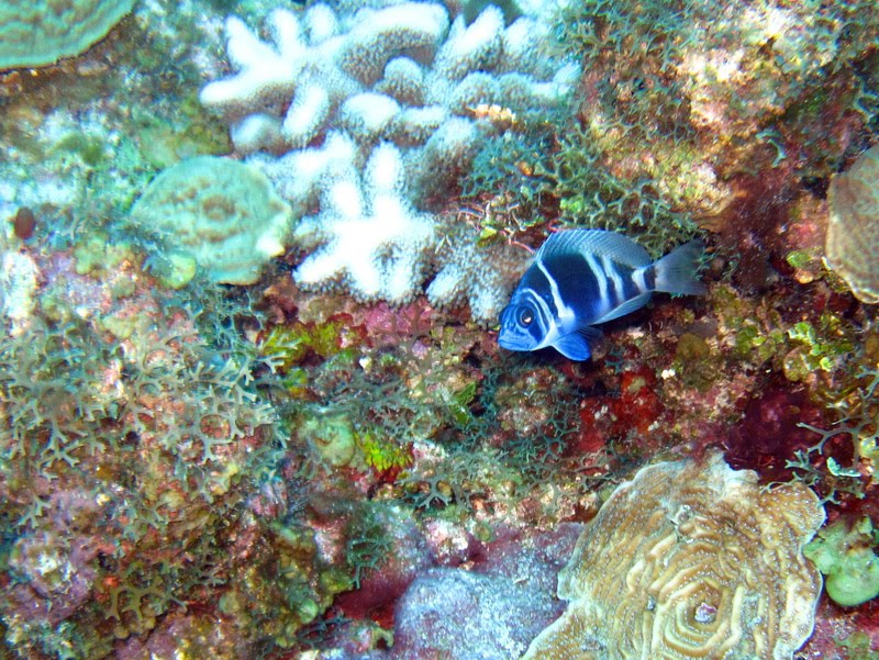
Poor lighting on the fish, he wasn a little skiddish and I couldn't get very close.


This lobster was about 24 inches tip to tail and would have been great on a plate. We were in the marine reserve, so I didn't try to grab him.


This is Capt Joe reaching for a 36 inch barracuda


This is the dreaded lion fish, he was in about 65 foot of water, Capt Joe took off his gear at 65 feet so he could take off hit tshirt to make a net out of it. We actually had this guy netted for a bit before he escaped. Joe was going to take him to the surface to dispose of him.


Trigger fish... also inspiration for some of the animation movies, but I don't recall which one.


I felt like a sorority girl here taking this picture of my self! Ha


One of my favorite most colorful fish, a Queen Angel. I use to see them on almost every dive in Cozumel, but they are pretty rare today. Not sure if it is the location or the general decrease of the quantity of this fish.

Friday, November 20, 2009

Friday Plans

From an email with the National Park in Belize

Subject: Re: BACALAR CHICO NATIONAL PARK

Hey Charlie;

Well I should be back at the reserve on thursday and will probably try to give you a visit on friday so that we can plan to take out a day to go and take some pictures of bleaching and other stuff. Also to see if we can take some GPS points and then you can give us some more points where we can put in more marker buoys.

We want to properly demarkate all the different zones (conservation, preservation, and general use zones) and also would like to put a buoy in the back are of the reserve (back side where our station is located).

After we are finish with that I would like to see if we can do some water work and photograph and identify all the corals, fishes and marine creatures we find at Bacalarchico.

----

I'll consider this my charity work for Belize! Hopefully, I'll be in some areas diving that are protected and not open to anyone. Could be some pristine areas.

Tuesday, November 3, 2009

Lion Fish Spotted!


This is bad news: http://www.7newsbelize.com/sstory.php?nid=13278


Tomorrow (Tuesday) First Air / CPR classes

Saturday, November 29, 2008

BACALAR CHICO NATIONAL PARK - Friday

BACALAR CHICO NATIONAL PARK

All that portion of the Caribbean Sea and Land being Ambergris Caye, in theBelize District, comprising approximately 28,148 acres and bounded on the North by the International Boundary between Belize and Mexico; on the East by a 1,207metres (3/4 miles) buffer east of the reef crest; on the South by the Caribbean Sea, parts of Robles and parts of land now or formerly known as the Pinkerton Estate; and on the West by a north-south line between Ambergris Caye and Deer Caye.


I spent most of my day working on determining where the South park boundary was. Dinner guests at Thanksgiving were staff from the park. There was some question on where the park began, and where it ended.

We had some pretty sketchy details as far as some landmarks, but nothing decisive. We discovered some documentation on lat/lon but it was based on North American Datum 1927, based at Meads Ranch Kansas! (Yes, I have been to the point and seen the markers).

Needless to say, we needed some updated coordinates. While I am sure the new coordinates I determined are not 100% accurate, it was much better than we had going into it.

Three of us took off to the waters to identify and install a couple of buoys to identify the South side of the park.

This is a very important step, as inside the park is protected waters. Kinda hard to protect if you don't know the boundaries.

Another day, another civic duty done